| A Trip to the Southwest and the Plains November/December 2007 Little Rock — Page 1 |
On the Road to Sallisaw
When we arrived in Wichita the motorhome fuel tank was down to being only
one forth full. As we prepared to leave town, my plan was to fill the fuel
tank at a station a few blocks from the RV campground that was on the way
to the highway. As I drove into the pump area I found that there were no diesel
pumps yet there was a sign out front that had a price for diesel fuel. I looked
around and discovered there were diesel pumps behind the station. With the
street next to the station being one-way and me towing a car, I was not able
to simply go back around to enter the diesel fueling area. Oh well —
I continued on our way with the idea to find fuel along the highway.
Then we headed for the Kansas Turnpike to go south into Oklahoma. The Kansas Turnpike has travel centers spaced along the route between Kansas City and the Oklahoma border. An interesting feature of these service areas is that they are located between the two opposing lanes of traffic such that the exit from the highway to the service facility is made from the left or high speed lane. This makes it possible to have only one service area for both directions of traffic.
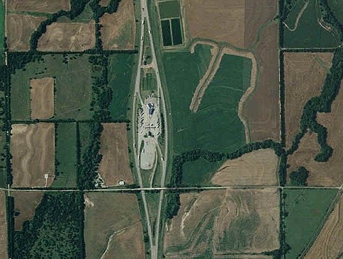 Aerial view of a Kansas Turnpike travel center — Photo from Mapquest.com |
The travel center south of Wichita was my first opportunity to refuel before getting to Oklahoma. I moved into the left lane and exited the turnpike going into the travel center and slowly drove toward the wide pump island area. I looked at the islands ahead and saw pumps with green hoses on all the pumps I could see. Off to the left there was an empty island and I headed that way. Unfortunately, I was not able to see the hoses on the pumps until I was committed to driving through. Only then I saw that this island had only gasoline pumps — no green hoses.
I just sat there for a while calculating in my head whether or not I had enough fuel to get to a station in Oklahoma. The traffic pattern was one-way and from what I could see there was no way to get to the other side of the travel center. There were a lot of tractor-trailer big-rigs parked in place and entering the area regularly. Normally it would have been easy to back up and go to a different pump island. With a car in tow, going in reverse was not an option and I didn't want to get out in the cold wind to unhook the car.
After watching how the vehicles arrived in groups with no activity before the next group arrived, I took a chance. I pulled through the fueling area and made a wide turn to the right which required going the wrong way against tractor-trailer traffic in a single lane. It worked with me now being able to get realigned to go to a diesel pump. No sooner than I was pulling up to a pump the next group of big-rigs and automobiles came in like a herd of thirsty animals. That was closer than I like, but it worked.
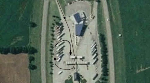 Route taken to get back to a diesel fuel pump — Photo from Mapquest.com |
Once back on the highway we began to think about a place to have lunch. Shortly after entering Oklahoma , a rest area appeared where I pulled off the highway. I went outside to look around and check on our towed car. As I looked around I was impressed with how many oil wells were pumping. In many of the oil fields in the plains, wells became uneconomical to pump a few years ago. However, with the price of oil being at record levels, many of the wells were put back into production. I counted twelve oil-well pumps in operation in the field next to the rest area.
Our plan was to find a way around Oklahoma City because of the very bad roads we've encountered in the past. Kay plotted a route that began at the Guthrie turn-off from I-35. Instead of going to Guthrie, we would go the other way, west on state highway 105 until we reached US-177 where we would go south to I-40. The roads are two lane apposing traffic, but the pavement was smoother than what we drove on near Oklahoma City in years past.
We had only one tense time on US-177. The roadway was narrow with only soft shoulders. Suddenly over a rise came a very wide load. A big-rig with a flatbed semi-trailer carrying what looked like a huge dump-truck bed that was as wide as one and half lanes. I slowed down and crept as close to the edge of the pavement as I could. The wide load driver was driving close to his side of the road as well. Even so, the wide load still stuck out quite a lot into my lane.
What made this a white-knuckle situation was the fact that the wide load truck was traveling about 60 miles per hour and it DID NOT slow down. I was driving about 10 miles per hour when the wide load whizzed past with the truck's side mirror missing my left rear-view mirror by what seemed like only a few inches. At the speed of the encounter, it felt as if I was about to lose the side mirror. I quickly looked back in the mirror to see the wide load hi-balling it over a rise behind us.
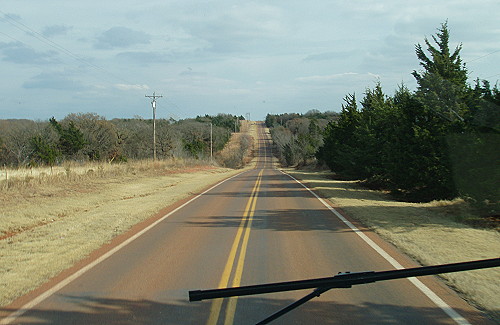 A smooth route to get around the bad roads in and near Oklahoma City |
As our new route took us through the countryside, new vistas appeared along the way. Bucolic scenes of farms with stereotypical buildings and small herds of farm animals were pleasant to see along the country road we were traveling through rural Oklahoma. Much of what we saw looked as if it could have been used as a subject for a Norman Rockwell painting like those found on old Saturday Evening Post magazine covers. This was a fun way to get from I-35 to I-40 as we headed to Arkansas.
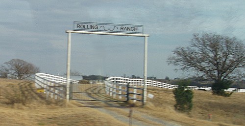 Entrance to one of many farms and ranches seen on back country road trip |
As we turned east on I-40, we entered new territory for us. We also saw the first of many billboards advertising Native American Casinos. I was impressed with the large number of different Indian nations represented by all the roadside casino ads. There also were several signs that would announce that we were entering or leaving Such-and-Such Nation territory or reservation. I saw familiar tribal names as well as names that were new to me.
Names familiar to me were Cherokee, Potawatomi, Shawnee, Seminole and Muskogee as well as Kickapoo and Pawnee. One name that sounds familiar, though spelled differently than I am used to, is Sequoyah — the name of the man who created the Cherokee alphabet. Located in California a type very big redwood tree that is called Sequoia.
Even though the names of Indian nations are seen in Oklahoma, many of the tribes — represented by those names — originated in the Eastern United States before being moved to reservations in the Western U.S. A name new to me was the Sac and Fox Nation. This is a tribe made up of two Native American peoples who originated in the Northeastern U.S.
As we were riding along on I-40 we began to see water areas appear here and there on both sides of the highway. It turned out that we were seeing glimpses of the Eufaula Reservoir which is much, much larger than what we could see from the highway. Sometimes called Lake Eufaula, I would learn later that the lake was dedicated by President Johnson in the mid 1960s.
A short time after seeing the water of the reservoir, an information sign appeared that had a very appropriate name for the street that was at the other end of the freeway exit — the name on the sign is Lotawatah Rd. I thought this was not only a good name for a street in the area of the lake, but also the name is somewhat humorous.
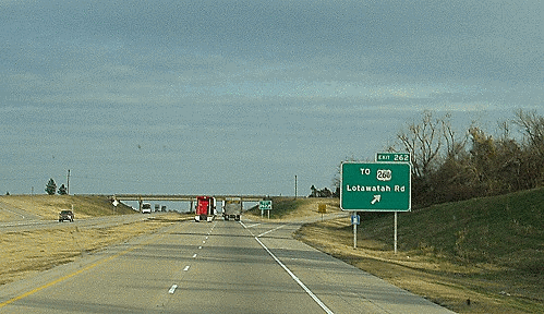 A street with a name befitting a road next to a lake |
The countryside we were driving through was rolling hills with hardwood forests. I guessed that this was the beginning of the Ozarks. After awhile our route took us across a river with a familiar name — the Arkansas River. A bit of trivia: Kansas is the only state where the river is pronounced, Ar-kan-sas River while everywhere else the Ar-kan-saw River pronunciation is used.
Shortly after crossing the Arkansas River we decided to stop for the night at the Sallisaw KOA RV campground. This turned out to be a good choice as this particular campground is a very nice example of an RV park. The owner/manager was very helpful, the small store was well stocked and best of all there was a solid Wi-Fi connection to the Internet that was no extra charge.
As it turned out, after learning about all the stuff to do in the area, I was wishing I could stay longer. I've made a note to return to this place during a future RV trek. For this trip, this was a nice place to stay after getting off the road before dark. We spent the evening watching TV and I went online to check my email.
| [ BEGIN ] | [ PREV ] | [ NEXT ] | [ RV FUN TRIPS ] |