|
Thanksgiving Trip 1999 Saturday 11-20-99 Page 1 |
We got under way at about 9 o'clock and headed south on Highway 85 to U.S. 101. The traffic was much lighter than I am used to along Highway 85. That is one of the nice things about starting our trip on a Saturday morning. We stopped at Campers World in San Martin for a little less than a half hour. The weather was partly cloudy with the type of clouds that provides what is sometimes referred to as "A photographers sky." We would have many different views of photographer's skies all through the day.
When we turned off of Highway 101 on to 152, there was a strong smell of garlic in the air. The food processing plant must have been working on a new batch of Gilroy's best known crop. As we drove over the Pacheco Pass, it became darker as the sky changed to mostly cloudy. There were only a couple of small blue sky patches to be seen until we passed San Luis Reservoir. Then the clouds opened to show about as much blue sky as clouds. As we drove down I-5, the clouds slowly thinned until we were driving down a corridor of mostly sunny sky with clouds over the mountains on both sides.
I-5 was pleasantly smooth compared to trips in the past. The old concrete has been covered with a layer of asphalt. Unfortunately, the concrete has failed in a few placed under the new pavement, leaving the familiar road bumps. Fortunately these bumps are few in number.
While driving south on I-5 it appeared as if the cotton field crops had been harvested recently. The fields had rows of huge bails of cotton lined up around the perimeter of the fields. We were to see more cotton fields with bails of cotton after turning east on Highway 46. On 46 we also saw a large prison just before getting to the town of Wasco. Also, before reaching Wasco and after leaving Wasco, we saw acres and acres of roses. I don't think I've seen so many roses in one place.
Shortly after turning south on Highway 99 we stopped at the Flying J north of Bakersfield to buy fuel. This was also a good opportunity to have lunch. From here we drove through Bakersfield turning east on Highway 58 and headed toward Tehachapi. Along the highway we passed by several orange tree orchards with trees loaded with ripe oranges. While our motorhome worked its way over the mountain we saw a lot of big freight trains going both directions. I know some people who would have really enjoyed watching the railroad activity.
As we drove through Tehachapi, it was very apparent that many new wind powered generators had been installed on the nearby mountain range. The generators are placed close together and there are so many generators that, from a distance, they look like a crop of strange wild flowers up on the mountain.
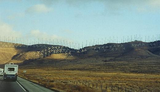
There are many more wind powered generators
than when we last passed by here.
The trip from Tehachapi down to the Mojave Desert was short. Coming down the mountain road we could see a nearly full moon rising over the horizon at about 2:30 in the afternoon. As we approached the town of Mojave we could see the air field where many out-of-service airliners are stored in the dry desert environment. This is also the home of the airplane designed by Dick Rutan that he and a companion flew non-stop around the world.
After finding our way through the town of Mojave, we headed out into the desert of the same name. On Highway 58 East, we saw several plants common to this area, Joshua trees. They aren't as promenant here as farther south.
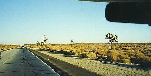
Joshua trees are very common in this part of the desert
After riding for awhile, we could see the sun setting in the rearview mirrors. It was about this time we passed the rocket engine test site.
When we arrived in Barstow, California there was only a hint of sunlight on the western horizon. The way we change from Highway 58 to I-40 has been changed from what we became used to over several trips through Barstow. The last time we came this way, the interchange was under construction and I missed the turnoff to I-40. I drove several miles before I found I had missed the exit. This trip, the construction is complete and the exit is marked, but in the dark I still missed the exit to I-40. But, this time we had our GPS receiver keeping track of our position. Kay quickly informed me I missed the turnoff, so I only had to go to the next freeway exit to turn around and get back on course. I don't know how I traveled without a GPS receiver in the past.
We drove on into the night toward Needles, California. As on our last trip, I was amazed at how far away we could see the glow in the sky from the lights of Las Vegas, Nevada. I must be getting used to the drive to Needles. When we drove over the mountains and saw the lights of the city below it looked good to me and the trip didn’t seem to take as long as it has in the past. We arrived at the KOA in Needles at about 7:45.
If you have comments or suggestions, please contact the .
All rights reserved. Copyright © 1999, Maurice Lambert